SSG 13: Grant Layup, Pitkin Yard Leads, and 76th St

Moving back into Brooklyn, we come to one of the most famous IND Second System provisions, matched only by S 4th St (Underbelly) in terms of notoriety. This provision is commonly known as the 76th St Provision, Grant Layup, or Pitkin Yard leads. A popular spot for explorers and graffiti writers (indeed, there is much notable historic graffiti inside), this spot rose to fame do to 50+ year old urban legend. Legend has it that the walls behind the bumper blocks on the lower level and the cinder block wall branching from the yard leads on the upper level are actually hollow, with a full set of tracks and a 76th St station shortly past.

Cinder block wall provision

So, why was this provision built in the first place? The IND originally intended to continue the Fulton St Line (which the A and C run on in Brooklyn) east into Queens down Pitkin Av and Linden Blvd, all the way to 229th St near the city limits. This extension would have served a large transportation desert, which now only has buses and the LIRR as options for rapid transit. To continue to this line, trains would have run through the lower level tunnel (Grant Layup, which isn’t much of a layup anymore) past where the wall and bumpers are. Trains also would have directly accessed the line from Pitkin Yard, which is why the upper level provision with the cinder block wall was built.

Concrete wall in lower level layup

Many people have wondered if the tunnel and 76th St station exist, and why they would be sealed. Joseph Brennan of Abandoned Stations came up with a conspiracy theory as an April Fools day joke many years ago about a coverup for non union labor. Somehow many people have read that article and taken it seriously. (Really, you believed that USAF officials came around the neighborhood asking about a tunnel?). The tunnel does contain signals that are very close to the bumpers/walls; there are rail ties installed on the upper level, and there is even a board in the Euclid Tower displaying a 76th St station and the interlocking. Despite these indicators, I am of the opinion that there is no 76th St station and no tunnel beyond the infamous wall. The sand behind the cinder block wall was probably just placed there to prevent flooding and water damage to the tunnel.

SSG 8: The Hillside Extension

While this spot serves as an important underground yard for one of the most important lines in the system, it is rarely photographed. The MTA tends to be protective of the most important underground layups, especially tail tracks (tracks that extend past a terminal station, increasing the line’s capacity). This specific layup/train relay turns Jamaica bound F trains back towards Manhattan and Brooklyn, along with select E trains during peak hours. It is the largest tail track layup in the system, with 2 levels of 4 tracks, giving it a turning capacity of over 60 trains per hour.

However, the reason for what could be seen as the overbuilding of this tunnel is the extension that was proposed for the IND Second System. The upper level was supposed to extend further down Hillside Ave all the way to Little Neck Rd; later down to Springfield Blvd. This extension deep into eastern Queens would have been highly beneficial to people living on or about Hillside Ave, and would have relieved what are now rather crowded buses and overwhelming traffic. There have been theories that the city actually did build a tunnel further under Hillside Ave, past the concrete wall at the end of the layup.

The Awaken team went to see if these theories had any grounding. I can say conclusively, after walking down Hillside Ave for about 3 miles (all the way to 232nd St) on a rather hot summer afternoon, checking the whole street and looking for signs of a tunnel, and also going down and inspecting the end of the layup, that there is no sign of any subway tunnel having been constructed past the end of the layup.

The actual tunnel isn’t very different from any other Queens Blvd tunnel, with the classic IND cut-and-cover box design and lots of brown snow. Notably, there is a lack of graffiti, aside from a few small tags here and there from legends such as Smith. A lack of heavy tagging tends to be a sign that a tunnel is special in some way, and I would say that this tunnel was no exception.

SSG 7: The Express Stop That Never Was (Updated)

As we wrap up our look at the IND Queens Blvd line’s mainline provisions, we must take a look at the express stop that never was: Woodhaven Blvd. Now a lonely average IND station, this local stop was once planned to be converted into an express stop.

As a part of the updated 1930s IND Second System plans, this station was constructed with 4 bellmouth provisions, one before and after the station on both local tracks. The intention of these provisions was to make it easier to build the tunnel out when eventually converting the station, as the local tracks would just run slightly further outside of the express tracks, creating room for island platforms on what are now currently the local tracks. The station was also built so that it would be easy to eventually lengthen the platforms.

Unfortunately for the city, the line that the reconstruction of this station would have depended on was never built. The express stop conversion was intended to allow better service to be provided to the line that the provision at 63rd Dr would have served.

Bellmouth provision east of Woodhaven Blvd

The truth is, this extra express stop is proof of just how much higher the capacity of Queens Blvd was intended to be than what it is today. The line was built to be able to serve two extensions, with the ability to someday serve four extensions if they were built. It could have even been 6 tracks for the mainline, had the super express tracks been built. Now enormous, overbuilt, lonely stations such as Woodhaven Blvd, Union Tpke-Kew Gardens, Parsons Blvd/Hillside Ave, 179th St, and more sit lonely, underwhelmed by the traffic they get now. The next post will be the last full post for the Queens Blvd line.

SSG 5: The Winfield Spur

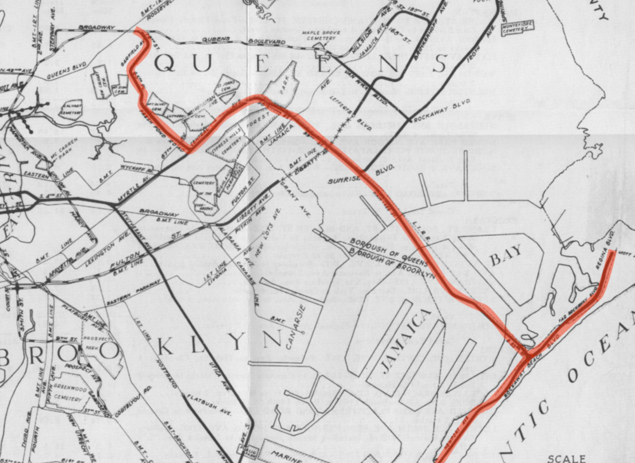
Looking at queens in terms of IND provisions, it would be impossible to neglect to mention this most notable of abandoned Second System relics: Roosevelt Ave Upper. This well known spot also may be known as the Winfield Spur. It includes a fully tiled station shell and a “spur” tunnel which runs above the Queens Blvd mainline and turns south at the east end of the provision. It was built during the original construction of the IND Queens Blvd line between 1933 and 1936, intended for full revenue service on a 2 track line going south through the neighborhoods of Maspeth, Ridgewood, and eventually the Rockaways. On the lower level, there are 2 provisional trackways hugging the mainline, which would have allowed Queens Blvd local trains coming from/going to Manhattan to run up through the Winfield Spur and join the line heading south.

The IND was serious about constructing this line—so serious, in fact, that the Roosevelt Av Upper station was actually fully tiled, unlike other IND station shells. The serious plans (from 1929) to use this station and the trackways beyond continued for nearly 10 years, dying out sometime in the late 1930s when it was decided that the new branch should extend from an area of Queens Blvd further east, near Rego Park.

The abandoned Rockaway Beach branch ROW

The line was intended to run underground through much of Queens and Brooklyn, actually joining another line which was planned to run up Myrtle Ave, branching from the S 4th St hub. After running up Central Av, the line would have come above ground to run over an already built LIRR Right of Way (the Rockaway Beach Branch). This Right of Way actually largely lays in decay now, after being abandoned in 1962. Some of the Right of Way (the bridge over Jamaica Bay into the Rockaways and the line in the Rockaways) was converted for use by the Transit Authority in 1955, and in 1956 the IND Rockaway Line (coming from the IND Fulton St Line) began operation. The (A) train now uses this southeastern branch full time, along with the Rockaway Shuttle. However, a large section of the ROW is still abandoned, and it would have been much better put to use as a subway line than what it is now: a somewhat nice place to walk and a breeding ground for mosquitoes.

As for what it is now, the space has not gone to complete waste. Although its story in terms of helping the city and the commuter, and providing rapid transit to underserved neighborhoods came to an end the way most IND Second System stories did, with the Great Depression and World War II draining the city’s and country’s resources to build rail infrastructure, the station shell is now used for storage and office space for the MTA. The tunnel does lay rotting, however. One trackway is nearly completely filled with garbage and the rest lay dark and lonely, never seeing light except from the occasional MTA worker, graffiti artist, or explorer. The construction is the standard IND Cut and Cover still, looking as boxy as ever. Also like usual, the abandoned tunnel is pitch black and extremely dirty. It is a true shame it will never get to see train headlights.

SSG 4: The East Broadway Provision

Continuing down what would have been the IND Worth St Line, one crosses the East Broadway (F) station. East Broadway would have run nearly directly perpendicular to the Second System line heading toward Brooklyn. As such, East Broadway was originally planned to serve as a convenient transfer point and a station twice its current size. One may notice while walking through the station that there are numerous dark and dirty staircases locked behind gates, and many locked doors in the public mezzanine. This is because the public station is but a husk of what was constructed.

The station was actually built with a full length intermediate level mezzanine which is also a provision for a station for the Worth St line. Tracks and a platform would have extended West-East in the middle of this intermediate level, perpendicular to the active station. As stated in the previous post, the line would have been highly beneficial to Brooklyn commuters, bringing full subway service to “transportation deserts” and also taking pressure off of elevated lines and more unreliable two track lines such as the (L). From this station, trains would have continued through a new crossriver tunnel into Williamsburg, into the S 4th St hub.

Below the provision, the East Broadway station is heavily deteriorating and will probably be due for a Station Renovation or Enhanced Station Initiative soon. Like other (F) line stations, especially on the Lower East Side, the station is regularly inhabited by the homeless and overwhelmingly reeks of urine in many areas.

The provision itself is rather dark and dirty, covered in “brown snow”. A portion is tiled like any plain IND mezzanine would be. The space is now used for storage and break rooms by Stations personnel. While this area will probably never see revenue service or customers, it is certainly cool to look at, especially being rarely photographed.

SSG 3: IND Worth St Line Provisions (Updated)

Another highlight of the IND Second System was the IND Worth St Line. The Worth St line would have been fed by 8th Av Line trains and would have fed to other major IND Second System lines, making it a key component of the whole plan.

Provisions were built for the IND Worth St Line during both original IND 8th Av line and IND 6th Av line construction, though this post will focus on the provisions constructed on the 8th Av line.

Bellmouth on northbound track

Bellmouth on northbound track

These provisions (empty tunnel bellmouths within the active tunnel) would have allowed the line that terminates at Chambers St-World Trade Center, currently the (E) line, to instead continue East across Worth St, through a new crossriver tunnel, and through the S 4th St station hub and under Myrtle Av or Stuyvesant Av and Utica Av in Brooklyn. This new subway in Brooklyn also would have been fed by trains coming from 6th Av, through the provision for a crossriver to Brooklyn at 2nd Av.

The state of this place today is not unlike other IND Second System provisions, being dark and water damaged in some areas. In this tunnel, the tracks split into two levels, in order to allow the (E) to move into its own terminal platform and the (A) and (C) to continue to Brooklyn on their own separate platform. The southbound (C) merges onto the (A) express track, while the (E) local track sinks underneath and crosses below the southbound and northbound express tracks to come up adjacent to the northbound local track. The provision for the Worth St line extends from both local tracks on both levels, the upper level one (shown) being slightly shorter than the lower level.

Bellmouth on southbound track (lower level)

Technicalities aside, the Worth St Line and various Brooklyn lines it would have fed would have greatly benefitted the city, and it’s a shame that a combination of unfortunate circumstances prevented their construction, along with most of the Second System. Today, these lines and provisions still hold relevance, as the MTA and the public have recently reopened discussion of a Utica Av subway in Brooklyn, with the MTA reviewing the feasibility of extending the IRT Eastern Parkway Line in Brooklyn south down Utica Av (the IRT also included a provision for a Utica Av line at the Crown Heights-Utica Av station—but that is a story for another series). Unfortunately, I don’t think we will ever see any of these proposed lines constructed, certainly not any time soon. However, it is nice to appreciate the ambition that the city once had for new subway construction at a time by admiring the forward thinking construction of the IND “First System” lines.