IRT Intricacies 3: 18th St

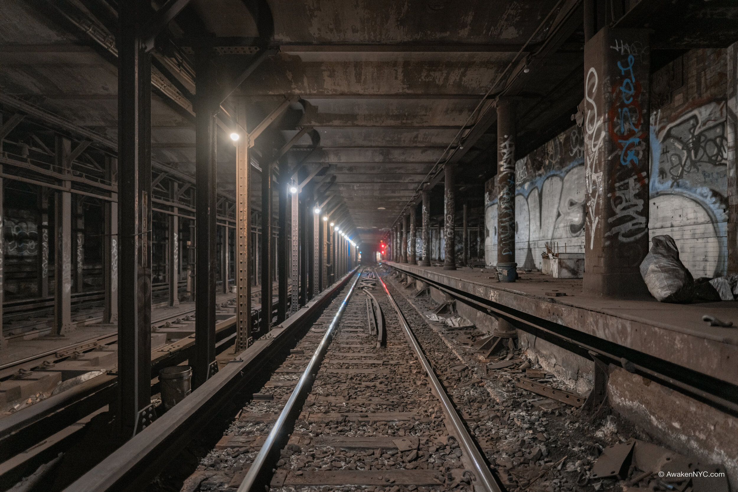
Continuing up the original IRT subway, we arrive at our next abandoned station: 18th Street. 18th St was put in service with the rest of the IRT line from City Hall to 145th St on October 27th, 1904, with two 5-car side platforms, as was the standard for the IRT local stations.

As platform lengthening spread through the system, the 23rd St station (the next stop going north) was extended south, and the 14th St-Union Square station was extended north. With the average NYC block being about 264 feet long between consecutive streets, it was illogical to have the three stations so close together. As a result, 18th St outlived its useful life, and it was removed from service on November 8th, 1948.

IRT Intricacies 2: Worth St

After posting the first edition to this series, I realized that I left out something very important—what IRT actually means. The IRT was the Interborough Rapid Transit Company, the first of the three companies in NYC that ran subways. Soon after the creation of the IRT came the BRT (Brooklyn Rapid Transit Company, replaced by the BMT—Brooklyn Manhattan Transit Corporation), and finally in 1932, the city-owned and city-operated IND (Independent Subway System).

Going up the original IRT subway line, we come to the first abandoned station: Worth St. Unlike other abandoned IRT stations, the west platform (formerly the southbound local platform) is full length, fitting 10 car trains. Stations on the original IRT line were built with 5 car platforms, with all but the abandoned stations soon being extended to 10 cars. The northbound Worth St platform was left at 5 car-lengths.

The Worth St station was abandoned after the next station south, Brooklyn Bridge-City Hall was extended to 10 cars. Since the Brooklyn Bridge station was extended north towards Worth St (due to the south end of the station being in close proximity to the City Hall interlocking), the Worth St station outlived its useful life.

IRT Intricacies 1: City Hall Loop

It’s only appropriate to start this IRT-focused series with a City Hall loop post. This iconic spot is probably the most well known abandoned station in NYC, and for good reason. The station was designed by Rafael Guastavino and features breathtaking architecture, with arched ceilings, colored tiles, chandeliers, and skylights. It was designed to be the crown of the original IRT subway—the first subway line in NYC—opening with the rest of the line up to 145th St on October 27th, 1904.

As time went on, the IRT lengthened trains and stations from 5 cars to 10 cars to increase capacity. This would be the downfall of the City Hall loop station: since it was built so close to the Brooklyn Bridge station, an express stop, it was illogical to lengthen the City Hall platform to 10 cars. As a result, revenue service at the station was discontinued on December 31st, 1945. However, the loop is still used to turn (6) trains from the downtown to the uptown track, as Brooklyn Bridge is the southern terminal station. It is still possible to see the station without endangering oneself: the Transit Museum offers tours a few times a year to members, though tickets sell out quickly; it is also possible to stay on the (6) train after Brooklyn Bridge, the station is visible through the window (although this is technically against the rules, it’s unlikely anyone will stop you). Also, to make it very clear, I do NOT condone “subway surfing” into the station. It is dangerous and people often get hurt trying this method of entry.

This series will heavily focus on the original IRT subway line, which ran up the East Side, across 42nd St, and up the West Side, starting at City Hall and terminating at 145th St/Broadway. This original line has many interesting artifacts of another time, for which there is plenty to write. That’s not to say there won’t be some focus on other lines—there are definitely many more “IRT Intricacies” outside of the original line and outside of Manhattan, and I am excited to discuss them.

SSG 17: The Bronx Provision

The Bronx, in terms of rapid transit service, is traditionally seen as IRT territory. The IND only built a single line (with just 3 tracks) in the Bronx, under Grand Concourse—a line which is parallel with the IRT Jerome Av line and is just 2-4 blocks east of it. This line is now serviced by the B and D trains, with D trains running all times to 205th St, and B trains running on peak to Bedford Park Blvd—the second to last stop. Off peak, B trains terminate at 145th St, and the B doesn’t run during late nights or weekends. This makes the Concourse line a rather lonely one. While the IND didn’t have huge plans for the Bronx, the Second System did provide for a significant extension of the Concourse line and construction of a line (with a couple branches) in the eastern Bronx, as the northern segment of the Second Avenue Subway (a lot more on this in the next installment of this series).

Bumper block at the east end of the 205th St tail tracks

There is but one IND Second System provision that was constructed in the Bronx. The northern terminus of the Concourse line, at E 205th St in Norwood, has possibly the strangest track layout of any IND terminal station. It has tail tracks, but these are kept clear to be used as relay tracks (serving to turn trains around). There is no crossover between the northbound and southbound revenue tracks between Bedford Park Blvd and 205th St, so all revenue trains must pull into the station on what would be the northbound track, discharge passengers, move forward into the relay, and then reverse back onto the southbound track (trains may switch tracks when pulling into the relay, or when pulling out after reversing). Trains may also come into 205th St directly from the Concourse Yard on a middle track west of the station (railroad south), going directly into service at 205th St.

Track layout of Bedford Park Blvd, Concourse Yard, and 205th St area

The reason for the odd track layout of this area is simple: 205th St was not intended to be the permanent terminus of the line. The Second System plans called for the line to be extended to Boston Road and Baychester Av, next to the present day site of Co-Op City. This extension would have improved the commute of many Bronx residents, eliminating much reliability on slow bus routes.

SSG 16: Secrets of the G Line

The IND Crosstown line, better known as the G line, is often characterized as a lonely, underutilized line. The reality is that it is a relic of a different New York. It is a line that was supposed to have been interwoven with other lines (planned for the IND Second System) branching through Manhattan, Brooklyn, and Queens, the plans for which never came to fruition.

As with nearly every single subway line built by the IND, the Crosstown line was built with a number of provisions for future expansion, in order to provide for easier connections to the planned lines. These include provisions for a Lafeyette Av line, Myrtle Av line to the Rockaways, and a Stuyvesant Av to Utica Av line. The latter two lines would have run through the S 4th St hub (better known as Underbelly), a station shell provision for which was built above the Broadway station.

Provision past Bedford-Nostrand Avs

The Lafayette Av line would have run from Manhattan (possibly as an extension of the planned 2nd Av line) via new crossriver tunnel, connecting to the G at or about Hoyt/Schermerhorn Sts and running up the Lafayette Av portion of the line. Past Bedford/Nostrand Avs where the current Crosstown line curves North onto Marcy Av, the Lafayette Av line would have continued East. Provisions for this extension were built at Classon Av and Bedford/Nostrand Avs, with a space for a middle track built at Classon Av (intended for layups/storage for short runs), and 2 tail tracks East of Bedford/Nostrand Avs. These tail tracks sink beneath the Crosstown line and head a short distance east before dead ending at bumpers.

Bedford-Nostrand Avs middle track

Classon Av provision

Three of these four provisions can be seen simply by standing on station platforms. The ones at Classon Av and Bedford/Nostrand Avs are pretty straightforward. The tail tracks east of Bedford/Nostrand are dark, damp, and dirty, as is the S 4th St station shell. Today, the middle track and tail tracks at Bedford/Nostrand are occasionally used for short term train storage, especially for garbage collection and other work trains.

SSG 15: Underbelly 2 - Utica Av Upper

S 4th St station shell, AKA “The Underbelly Project”

As we move deeper into the IND Second System plans, it becomes apparent that the IND had big ideas for Brooklyn. One of these plans remains relevant to this day: the Utica Av line. Recently, the MTA began reviewing the feasibility of a Utica Av line as an extension of the IRT Eastern Parkway line (the 3 and 4). A subway going under Utica Av would serve an area which lacks good rapid transit option extremely well. The IND knew this even in the 1929 plan, and they planned accordingly. Several provisions were constructed to allow for other lines to feed into Utica Av, including provisions for the Worth St line, a new crossriver tunnel, and two station shells. The first station shell, built above the Broadway (G) station, was for the S 4th St station, now better known as “Underbelly,” due to the underground art installation titled the Underbelly Project.

The Utica Ave upper level provision

This post is about the second of the two station shells, which was constructed at the Utica Ave station on the Fulton St line (the A and C). The station would have likely been renamed Fulton St—Utica Av upon completion of the Utica Av line, had it ever been built. Furthermore, the Utica Av station contains an enormous full length intermediate level mezzanine, now used as a storage and utility area.

Closed Utica Ave mezzanine

The station shell itself is very dark and extremely hot and humid. There is barely any ventilation within the shell. It is somewhat dusty, though it is not nearly as bad as the “brown snow” in S 4th St. Completely unlike S 4th St, this spot has managed to remain clean for over 80 years, feeling like a sliver of untouched history in a system that has shown rather obvious signs of its age in recent years.